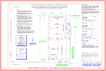
Subdivision Plat
A subdivision plat is a map or drawing that divides a larger parcel of land into smaller parts or lots. The subdivision plat can be small ie: 2 parcels or large ie: several hundred lots.
The subdivision is usually done under the authority of the municipality in which the property exists, such as City and/or County. The appropriate agency within the City or County, usually the Planning & Zoning Department will have specific guidelines that must be adhered to. Depending on zoning regulations and the size and use of the property, several types of surveys may be required before the final subdivision plat map can be produced. Such surveys may include a) ALTA/ACSM Land Title Survey, b) Topographic Survey.
The final subdivision plat map, upon acceptance with the appropriate governing agency will be deposited with the Clerk and Recorder of the county. The map will depict all the lots that were created simultaneously by the plat as well as provide for the dedication of street right-of-ways and easements. Markers and monuments will be placed and established along the perimeter of the subdivision and at each newly created lot, tract and street right-of-way.